


Mobile Topographer Free


Descripción de Mobile Topographer Free
Your mobile Topographer!
The leading tool for the professional surveyor or anyone who wants to mark his property, offering the best accuracy and extensive functionality that no other app can!
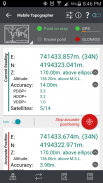
*** Increase GPS accuracy using:
- Weighted averaging (on every axis).
- Map calibration.
- Device calibration on map, or on a know point.
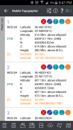
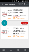
*** Display and convert GPS geodetic to Cartesian EN coordinates and back:
- UTM.
- Europe ETRS89/UTMZ28-38.
- Hellas HGRS 87 (EGSA 87).
- Hellas HGRS 87 - HEPOS.
- Hellas HTRS07/TM07.
- Iceland ISN93/Lambert 93.
- Morocco Merchich.
- SPCS83 (124 zones) USA.
- Romania S-42(58)/Stereo 70.
- Lebanon & Syria Deir ez Zor/Stereo.
- Croatia HTRS96/TM.
- Serbia SRB-ETRS89/UTM, SRB-MGI/Z7.
- Australia MGA94 (GDA94), AMG66 (AGD66) National, A.C.T., Northern Territory, NSW & Victoria, Tasmania,AMG84 (AGD84).
- Former FR of Yugoslavia MGI Balkans zones 5,6 & 7.
- Italy Monte Mario West Zone 1 Peninsular, West Zone 1 Sardinia, East Zone 2 Peninsular, East Zone 2 Sicily.
- Costa Rica CΜ05/CRTM05, Ocotepeque 1935 Costa Rica Norte & Ocotepeque 1935 Costa Rica Sur.
- Cyprus CGRS-93-LTM.
- Hungary HD72/EOV.
- Kosovo KosovaREF01.
- Latvia LKS92/TM.
- Lithuania LKS94/TM.
- Spain ED50/UTMZ29-30 NW, ED50/UTMZ29-31 ML & ED50/UTMZ31 BA.
- Uk's OSTN02/OSGM02.
- Turkey ED50/Gauss-Kruger 3° Z9-15, ITRF96 & ED50/UTMZ35-38.
- Luxembourg LUREF.
- Venezuala REGVEN/Z18-20.
- Sweden SWEREF99 TM.
- Argentina POSGAR 94 & POSGAR 2007.
- India Kalianpur 1975 ZI - ZIV.
- Algeria Nord Sahara 1959 / Z29-32.
- Armenia, Georgia, Azerbaijan, Estonia, Latvia, Lithuania, Russia - Kaliningrad and Kazakhstan Pulkovo 1942/ CS63 (A)Z1-4, (C)Z0-2, (K)Z2-4.
- Central and South America SIRGAS 2000.
- Nigeria and Cameroon Minna 1996 & 2008 MTM West, Mid, East Belts & UTM Z31-33.
- Bangladesh Gulshan 303/TM.
- France RGF93/CC42-50.
- Canada CSRS
- Egypt 1907 Blue, Red, Purple, Extended Purple belts.
- Portugal ETRS89/PTM06.
- Netherlands Amersfoort/RD new.
- Qatar QND95.
- Colombia MAGNA-SIRGAS Far West, West, Bogota, Central East, East zones.
- Mexico ITRF 2008/LCC.
- Madagascar Tananariva (Paris)/Laborde & Tananariva/UTM Z38-39S .
- Tunisia Carthage (Paris)/Mining Grid, Carthage/Nord, Carthage/Sud, Carthage/TM 11 NE, Carthage/UTM zone 32N.
- Liechtenstein CH1903/LV03C-G.
- Switzerland CH1903/LV03 (old), CH1903+/LV95 (new).
- Brazil SAD69/UTM Z18-25 & SAD69(96)/UTM Z18-25
- Spain Canary Islands REGCAN95/LAEA & REGCAN95/LCC & REGCAN95/UTM Z27-28
*** Auto stop for accurate positioning.
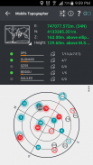
*** Examine the satellites above you in a sky view.
*** Signal strength and number of satellites indication for each GNSS constellation individually.
*** Multiple units support:
- Meters,
- International feet,
- US survey feet.
***Height calculation:
- Ellipsoidal height.
- EGM96 orthometric height calculation.
*** Convert from geodetic to Cartesian coordinates and back:
- Support for device measured points, or
- Manually input of geodetic or Cartesian coords.
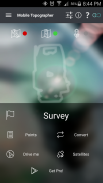
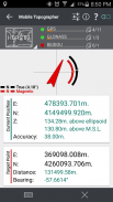
*** Drive me:
- Key in coordinates of the target point in either geodetic or Cartesian coordinates, or select a point from the list and follow the pointer.
- Compass indicating both magnetic and true North.
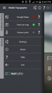
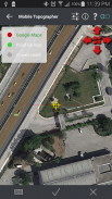
*** Project on Map:
- Project individual points on any map application.
- Project list of points, and the defined polygon, on embedded maps.
*** Save multiple point lists, to use them later.
*** Calculate area.
*** Export point lists το:
- .txt (text file)
- .csv (point file - comma separated)
- .kml (google earth file)
- .gpx (Gps Exchange format)
- .dxf (drawing file)
*** Send file via e-mail, or upload it to cloud.
*** Complete help text support.
Help us improve Mobile Topographer by e-mailing your comments and suggestions.
TAGS: Survey Surveyor Property GPS GNSS GLONASS QZSS BEIDOU GALILEO
Su topógrafo móvil!
La herramienta principal para el topógrafo profesional o cualquier persona que quiera marcar su propiedad, que ofrece la mejor precisión y una amplia funcionalidad que ninguna otra aplicación puede!
*** Aumentar la precisión del GPS usando:
- Un promedio ponderado (en cada eje).
- Calibración de mapas.
- Dispositivo de calibración en el mapa, o en un punto de conocimientos.
*** Display y convertir geodésica GPS para cartesiana ES coordenadas y la espalda:
- UTM.
- Europa ETRS89 / UTMZ28-38.
- Hellas HGRS 87 (EGSA 87).
- Hellas HGRS 87 - HEPOS.
- Hellas HTRS07 / TM07.
- Islandia ISN93 / 93 Lambert.
- Marruecos Merchich.
- SPCS83 zonas (124) EE.UU..
- Rumanía S-42 (58) / estéreo 70.
- Líbano y Siria Deir ez Zor / estéreo.
- Croacia HTRS96 / TM.
- Serbia SRB-ETRS89 / UTM, SRB-MGI / Z7.
- Australia MGA94 (GDA94), AMG66 (AGD66) Nacional, A.C.T., Territorio del Norte, Nueva Gales del Sur y Victoria, Tasmania, AMG84 (AGD84).
- El ex Yugoslavia FR de las zonas de los Balcanes MGI 5,6 y 7.
- Italia Monte Mario West Zona 1 peninsular, Zona Oeste 1 Cerdeña, Zona Este peninsular 2, 2 Zona Este Sicilia.
- Costa Rica CΜ05 / CRTM05, Ocotepeque 1935 Costa Rica Norte y Ocotepeque 1935 Costa Rica Sur.
- Chipre CGRS-93-LTM.
- Hungría HD72 / VEE.
- Kosovo KosovaREF01.
- Letonia LKS92 / TM.
- Lituania LKS94 / TM.
- España ED50 / UTMZ29-30 NW, ED50 / ED50 UTMZ29-31 ML y / UTMZ31 BA.
- UK OSTN02 / OSGM02.
- Turquía ED50 / Gauss-Kruger 3 ° Z9-15, ITRF96 y ED50 / UTMZ35-38.
- Luxemburgo LUREF.
- Venezuala REGVEN / Z18-20.
- Suecia SWEREF99 TM.
- Argentina POSGAR 94 & POSGAR 2007.
- India Kalianpur 1975 ZI - ZIV.
- Argelia Nord Sahara 1959 / Z29-32.
- Armenia, Georgia, Azerbaiyán, Estonia, Latvia, Lituania, Rusia - Kaliningrado y Kazajstán Pulkovo 1942 / CS63 (A) Z1-4, (C) Z0-2, (K) Z2-4.
- América Central y del Sur SIRGAS 2000.
- Nigeria y Camerún Minna el 1996 y 2008 MTM West, mediana, Cinturones East & UTM Z31-33.
- Bangladesh Gulshan 303 / TM.
- Francia RGF93 / CC42-50.
- CSRS Canadá
- Egipto 1907 azul, rojo, púrpura, púrpura Extended cinturones.
- Portugal ETRS89 / PTM06.
- Países Bajos Amersfoort / RD nueva.
- Qatar QND95.
- Colombia MAGNA-SIRGAS Far West, West, Bogotá, Centro Oriente, zonas de Oriente.
- México ITRF 2008 / LCC.
- Madagascar Tananariva (París) / Laborde y Tananariva / UTM Z38-39S.
- Túnez Cartago (París) / Minería de cuadrícula, Cartago / Nord, Cartago / Sud, Cartago / TM 11 NE, Cartago / UTM zone 32N.
- Liechtenstein CH1903 / LV03C-G.
- Suiza CH1903 / LV03 (antiguo), CH1903 + / LV95 (nuevo).
- Brasil SAD69 / UTM Z18-25 y SAD69 (96) / UTM Z18-25
- Islas Canarias España REGCAN95 / LAEA y REGCAN95 / LCC y REGCAN95 / UTM Z27-28
*** Parada automática para el posicionamiento preciso.
*** Examinar los satélites sobre usted en una vista del cielo.
*** Intensidad de la señal y el número de satélites indicación para cada constelación GNSS de forma individual.
*** Varias unidades de apoyo:
- Medidores,
- pies internacionales,
- Los pies de la encuesta de Estados Unidos.
*** Cálculo Altura:
- Altura elipsoidal.
- EGM96 cálculo de la altura ortométrica.
*** Convertir desde geodésico de coordenadas cartesianas y la espalda:
- Soporte para el dispositivo medido puntos, o
- Entrada manual de coordenadas geodésicas o cartesianas.
*** Condúceme:
- Teclear coordenadas del punto de destino en coordenadas cartesianas o geodésicas, ya sea, o seleccionar un punto de la lista y siga el puntero.
- Brújula que indica tanto magnético y el norte verdadero.
*** Proyecto en el mapa:
- Proyecto de puntos individuales en cualquier aplicación de mapas.
- La lista de Proyectos de puntos, y el polígono definido, en los mapas integrados.
*** Guardar varias listas de puntos, para usarlos más tarde.
*** Calcular el área.
*** Listas de puntos de exportación το:
- .txt (Archivo de texto)
- CSV (archivo de punto - separados por comas)
- .kml (Archivo google earth)
- Gpx (GPS eXchange Format)
- .dxf (Archivo de dibujo)
*** Enviar archivos a través de correo electrónico o subirlo a la nube.
*** Ayudan a apoyar el texto completo.
Ayudenos a mejorar topógrafo móvil enviando un correo electrónico a sus comentarios y sugerencias.
TAGS: Encuesta de arquitectos GPS GNSS GLONASS QZSS BEIDOU GALILEO
Mobile Topographer Free - Versión 9.3.2
(22-05-2019)

Mobile Topographer Free - Información de APK
Version de la app: 9.3.2Paquete: gr.stasta.mobiletopographerÚltima versión de Mobile Topographer Free
Otras versiones


Apps en la misma categoría

Quizá también te interese...


